How to Use Street View Rendering for Landscape Architecture Projects
Street View Rendering helps to create ideas for building aesthetic landscapes. It delivers an immersive realistic outcome that improves decision-making capabilities. This technology allows experts to deliver accurate work and the best results. It allows them to translate your concepts into real designs.
LOOKING FOR TOP-NOTCH RENDERING SERVICES? SMA ARCHVIZ OFFERS EXCEPTIONAL SOLUTIONS TO MEET ALL YOUR NEEDS.
What is Street View Rendering?
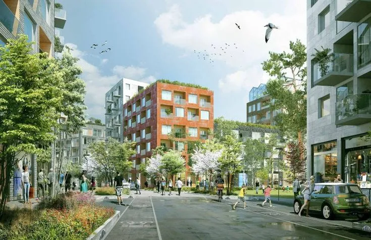
Street View Rendering allows architects and designers to visualize projects in a real-world environment. It combines photographic data with digital models to create realistic presentations. This technique ensures better planning, accurate scale, and a clear understanding of how elements fit within a given space. This method differs from 2D drawings because it provides an interactive way. This method lets designers connect abstract ideas to concrete garden creation designs.
Benefits of Street View Rendering in Landscape Architecture
Landscape architecture takes site rendering as an essential tool for protocol transitions between design concepts and actual look. Experts use this tool as a union of true-to-life scenarios that let them modify details. It ensures spaces merge smoothly with their surrounding areas.
Realistic Visualization
Traditional blueprints can be hard to interpret. With landscape site rendering, artists can present their ideas in a way that is easy to comprehend. Customers and shareholders can visualize how the final project will look in real life.
Improved Decision-Making
Architects use site rendering tools to detect possible design issues. These issues could occur before the start of construction operations. Early adjustments through this approach help avoid costly revisions that would appear later in the production sequence.
Enhanced Communication
The accurate graphics reduce the conflicts between architects, clients, and suppliers. This process reduces the confusion and speeds up the approval.
Better Integration with Surroundings
With urban and landscape planning, it is essential to see how new elements will fit into existing environments. This technology ensures harmony between old and new designs.
How to Use Street View Rendering for Landscape Projects
Step 1: Gather Site Data
The first step is collecting accurate site data. In this step, you have to include photos, maps, and area dimensions. Accurate renderings depend on the full data available.
Step 2: Create a Digital Model
A digital model of a setting is made with the help of 3D visualization services. These models include vegetation, terrain, water bodies, and pathways. The goal is to create a base model that mirrors real-world conditions.
Step 3: Integrate with Street View
Once the digital model is ready, it is integrated with site rendering. In this step, designers precisely place their models into actual settings. This way they check accurate size relations and positioning.
Step 4: Adjust Lighting and Textures
Designers need to modify realistic rendering elements with precise changes in shadows as well as lighting components and textural elements. This step guarantees that elements such as trees, structures, and roadways look natural in their environment.
Step 5: Present and Review
Finally, the visuals are shown to clients and all involved parties. After that, you can use their feedback to revise the design. Thus, you can fix all problems before moving on to initiating construction.
Applications of Street View Rendering in Landscape Architecture
Landscape Street View Rendering is a powerful tool in site architecture. It helps designers visualize outdoor spaces with accuracy. Stakeholders can evaluate the integration between plants, walkways, and built features with their settings. The method helps designers get quality through final design accuracy. The use of CAD in home gardens and Public Park planning ensures optimal designs. CAD reduces errors and offers a stronger presentation of conceptual frameworks.
Residential Landscape Design
Owners and designers can review garden plans, driveways, and outdoor layouts. Thus, they can alter the designs before the start of construction work.
Public Park Planning
Big park projects benefit from public park planning. It helps position pathways, green spaces, and amenities. So, they are optimized for proper functionality.
Commercial Developments
Commercial properties get the advantage of accurate rendering methods. These methods show how landscape areas link with architectural constructs.
Infrastructure Projects
New infrastructure logistics such as roads, bridges, and urban development projects become efficient. They can sustain disruptions in existing settings.
Choosing the Right Rendering Service
Working with experts always leads to the most ideal results. SMA Archviz offers elite 3D visualization services, producing reliable projects in each development phase. Expert support enables your landscape designs to reach refined accuracy. They also enhance aesthetic appeal and project market value. Working with skilled professionals provides project visual quality and smart management. An expert 3D visualization method covers the details including textures and lighting. It will help you make informed decisions before construction starts. With first-class renderings, you can effectively connect your vision to customers, investors, or shareholders, reducing the risk of errors and costly revisions.
NEED EXPERT RENDERING SOLUTIONS? CONTACT SMA ARCHVIZ TODAY AND BRING YOUR VISION TO LIFE!
Challenges and Solutions
Creating a detailed and realistic site plan rendering comes with its own set of challenges. From ensuring accuracy to picking the right software, every step needs careful planning. Errors or using the wrong tools can lead to unrealistic results. Additionally, it is hard to get suitable renderings within budget with cost limits. However, with the right methods and solutions, these challenges can be managed effectively. Below are some common issues faced during site plan rendering and how to overcome them.
Data Accuracy
- Challenge: Inaccurate data can lead to unrealistic renderings.
- Solution: Always verify site measurements and use high-resolution images.
Software Limitations
- Challenge: Some software lacks advanced features.
- Solution: Use industry-leading tools that support architectural site plan integration.
Cost Constraints
- Challenge: High-quality renderings can be expensive.
- Solution: Budget wisely and invest in efficient site plan rendering services.
Final Thoughts
Street View Rendering is transforming the landscape architecture industry. It enhances imagining, improves policymaking, and ensures improved project results. By incorporating this method, builders can craft useful, visually pleasing settings with confidence. Embrace the power of realistic site rendering for your next project and experience the difference it makes in design and execution.