Urban Planning Rendering: Enhancing City Development with Visual Precision
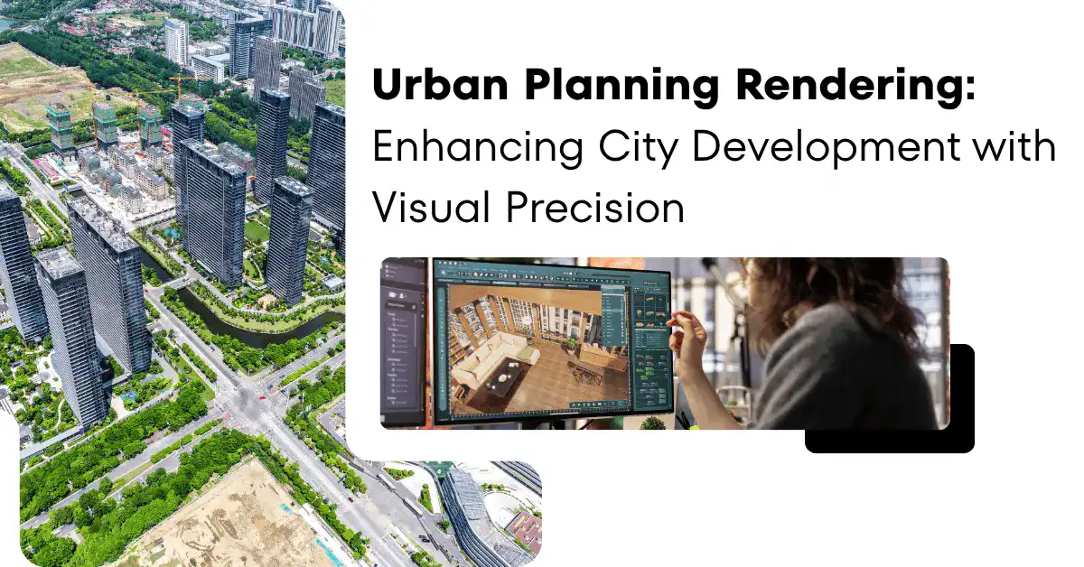
Cities are no longer built on only blueprints. They are shaped and approved with the help of detailed virtual environments before a single foundation is poured.
However, Urban planning rendering is one of the best presentation tools to make better decisions and greener outcomes. In the past, hand-drawn sketches and other manual methods used to take a lot of time. But now experts work on advanced software to create realistic three-dimensional digital visuals. They are in the form of three-dimensional images and animation. Everything looks so real like you are actually moving into a real constructed environment.
Get Urban Planning Rendering from experts to enhance City Development with Visual Precision!
Visual precision is enhancing city Development
From Static Drawings to Living Digital Worlds
For so many years, the planners communicated the designs through 2-D maps and hand-drawn elevations.
Today, 3D architectural visualization and 3D city modeling help all the team members work with the accuracy of an engineered document.
The platforms powered by spatial computing in planning can:
- ingest GIS data
- topographic surveys
- real-time traffic feeds
This matters because the perception drives consensus.
When a city council can walk through a corridor in virtual reality for city planning. They experience light and movement. It also helps to identify any flaws in the designs early. So no more wastage of money and no change orders. These are the modern methods that are converting modern planning processes:
- Digital twins for urban planning copy existing scenarios and allow the planners to make changes.
- Interactive 3D city maps that help planners to toggle between zoning layers.
- Real-time city rendering software lets the designer edit quickly. This removes the overnight render queue.
- Cloud-based rendering for AEC teams distributes load across remote infrastructure.
Sustainability and Climate Resilience, Made Visible
No other domain benefits that much more than sustainable design.
Sustainable architecture visualization allows project teams to communicate the performance of a building before it exists.
Solar analysis in 3D helps to look at the sun paths. Experts can look into the shadow issues.
For whole cities, 3D visuals can show green features like rain gardens, street trees, etc. This helps people see how these things will actually look and work in the city.
Flood-adaptive systems modeling shows what flooding might look like in the future. It provides details about sea level rise and rainfall data. This is to look how water could affect the area.
Designers working in biophilic urban design. They use high-detail greenery libraries.
They also use atmospheric rendering techniques to have ideas about nature.
Specific tools supporting this type of work include:
- Eco-friendly material rendering libraries accurately work with recycled timber, etc. This helps clients understand aesthetic trade-offs
- Energy-efficient building models are connected to performance simulation engines
- Resilient infrastructure to design processes combine GIS environment with semantic 3D city models to design vulnerability zones
Community Engagement and the Democratic City
A photorealistic render of a proposed project is equally important as the conversation it starts.
Modern planning agencies are now using community engagement visualization platforms. It helps them invite ordinary residents into the design process. They are active participants.
Public participation 3D portals helps them get the comments on specific elements. Plus, they explore interactive urban scenarios. Such as:
- What if this parking structure became a community garden?
- What if building heights were capped at six storeys instead of twelve?
This kind of stakeholder collaboration fills the gap between the technical expertise and lived neighbourhood knowledge.
It shows where people can afford to live. Plus, if they feel that the city plan is boring then they provide ideas which help in the overall planning.
When 3D pictures of these areas are created, it adds details like clothes hanging on lines, busy market stands, etc.
These realistic details show the heart of a community. It is not a simple or basic drawing.
Benefits of investing in visualization include:
- Faster planning approval visualization processes
- Stronger political support for infill. With the help of mixed-use development rendering shows, one can visualize pedestrian activity in animation rather than blank podium walls.
- Better outcomes are expected because augmented reality can be experienced on a smartphone.
Technical Precision
High-quality 3D rendering services are the best tools for investors. Competitive companies use BIM for urban development throughout the design phase.
With the help of VDC and BIM coordination workflows, one can detect clash detection in MEP systems before the work begins. This helps to remove conflicts.
Moreover, pre-construction simulation allows planners to look closely into safety and other scenarios in a virtual environment.
For large-scale projects, master plan rendering is best to achieve the desired visuals.
If you implement photorealistic urban renders through narrative lighting for urban spaces then more clients will be impressed by your work. Investors feel emotionally connected to the space.
Conclusion
In short, urban plan rendering is one of the most reliable techniques to design the space by making the right decisions. That is why planners must get architectural rendering services because experts use AI tools to add material texturing and other features into the scenario. With the help of professional cinematic storytelling in ArchViz, you can convert a collection of buildings into a legible vision of urban life.
